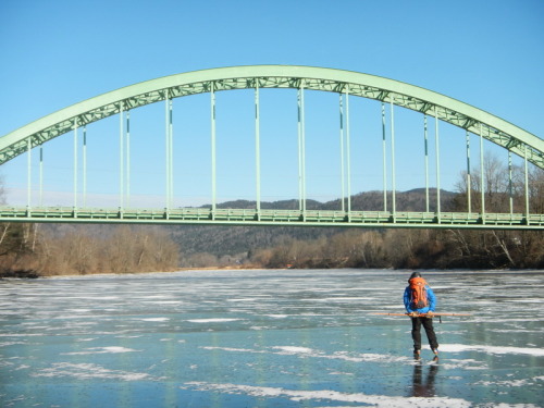
The Orford Bridge on the Connecticut River
Rivers and Moving Water
Summary: Ice over moving water behaves significantly differently than ice on lakes. The most prudent course of action is stay off of ice over rivers, tidal areas and areas of increased flow found in some lakes. On the other hand, when the ice is good, some rivers can offer a unique ice venue. If you go out on river ice, go with people who have considerable experience on the river of interest and take all the standard precautions (ice claws, test pole/drill/chisel, throw rope, life jacket, a buddy or two, waterproofed cell phone).
We strongly recommend staying off free flowing rivers as they usually have higher flow velocities and more irregular bottom profiles. Impounded rivers are a bit more predictable although they behave quite differently than lakes. .
Disclosure: at this point I have relatively little experience with rivers so what is stated here is preliminary.
There are a lot of obvious reasons why rivers are more problematic
- Their currents erode the ice from underneath.
- River ice can come and go more rapidly and less predictably than lake ice.
- If you do fall through there is the added risk of being swept under the ice, something you would be very unlikely to survive. This is an excellent reason to wear a life jacket and be skillful with your ice claws. See more about this risk below.
- There are a number of ice formation processed that are common on rivers that are not seen on lake ice: frazil can create large but irregular deposits under the ice and on the bottom of the river, Auf ice can form thick deposits on top. Both these things can result in highly variable ice thickness and could lead you to think the ice is uniformly much thicker than it is.
Other things to consider:
- Flow rates change a lot. Higher flow rate times are a not good time to be on the ice. Look at the NH river USGS site for information on flow rate history for the whole country. Remember to look at the previous week or two for high flow rate events. If your river is not covered, see what happened on a similar, nearby river. Many rivers that are big enough for skating also have hydro operations on them that will affect flow rates.
- In particular, rivers below dams with high volume lakes behind them have a complex temperature relationship. Early in the season a big lake will have a water tempeature of about 36 degrees. A river that is continously mixed by convection will not form an ice surface until the whole river is about 32.1 deg.
- Since water is coming out of a lake is likely to be about 36 degrees and will not freeze until it has run far enough though cold air to redue the whole river flow to 32 degrees.
- Under-ice erosion is somewhat held at bay by the usually very cold temperature of the water (on the order of 32.1 deg F). This is considerably colder than lakes once you get a foot or two under the ice sheet. In a lake, winter stagnation keeps the coldest water happily near the bottom of the ice sheet. In a river the current mixes the entire water column enough to keep it all at one temperature. A rough estimate of the erosion rate using the Stehpan Solution suggest the erosion rate might be as high as half an inch a day at 32.2 deg. If the growth rate resulting from cooling from the top is not sufficient to match the erosion rate the ice will loose thickness. A couple inches of insulating snow might allow under-ice erosion to dominate even in cold conditions.
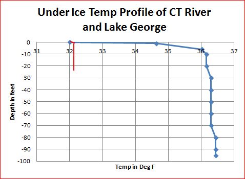
The Connecticut River Near Orford NH is a little over 20 feet deep. Its temperature was 32.1 degrees from the top to the bottom (red line) as a result of the turbulent mixing of the river. Lake George (NY) shows a typical deep lake temperature profile (blue curve).
- Warm conditions will melt the ice in the usual fashion and warm rain might allow the water temperature of the river to rise a little. That might cause a greater rise in the temperature of high gradient streams that quickly transport water from rain drops to the river. It is important to know the weather history.
There were four North American deaths during the 2013 ice season that involved people being swept under the ice after falling through. A rough estimate of the drag force on a person vertical in the water is:
- 0.3 mph (0.5 ft/sec): 1 lb (this was the speed of a maple seed just under the ice the Connecticut River measured on mid afternoon of 2/7/2013). This speed is likely to not be representative of other times and places.
- 1 mph (1.5 ft/sec): 11 lbs (not too far from the flotation provided by a life-jacket)
- 2 mph (3 ft/sec) : 44 lbs
- 4 mph (6 ft/sec): 175 lb: I do not know if 4 mph under-ice currents are common but falling through in anything much over 1 mph could be a dangerous affair. This risk is another reason to wear a life-jacket, have a throw rope and a buddy to throw it to as well as ice picks to make a fast exit from the water. In some circumstances all of this will be of little help. At four mph the current will carry a person at one body length per second: a very good reason to stay off ice on fast rivers.
You can get a rough idea of current speed if you can see through the ice. Scratch two lines in the ice across the flow direction and 3 feet apart. Watch for something drifting under the ice and time how long it takes to get between the lines. Keep in mind that something floating along the bottom of the ice sheet is in the boundary layer and is going more slowly than the bulk flow.
Rivers have several hazards that are not common on lakes. Most of these are from river skaters I have spoken with.
- Stream inlets of all types should be regarded as potential problem areas.
- Bridges over rivers often have thinner ice or open water near them.
- High gradient streams can put deltas into the side of the river that divert flow and are especially likely to create open/thin areas (see below).
- Changing water levels can create a puddle along the edge when the water level rises. When the water level drops, shore ice may be suspended in the air (and is likely to be weak without the underlying water).
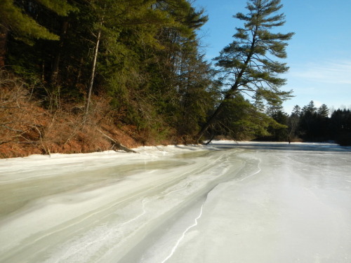
Folded shore ridge related to water level changes and expansion pressure on the CT River.
- Outside bends tend to have more problem areas. In general, the ice over the channel tends to be thinner and to melt first.
- Any area where the elevation gradient picks up is likely to be thinner or open as a result of the faster current.
- Industrial/power plant out flows of warmer water can create open/thin areas.
- Shipping traffic on bigger rivers.
- Reefs, sand bars and deltas are potential areas of thin ice.
- Impounded rivers are, in general, less hazardous than free running rivers.
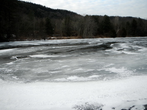
Above is a picture of open water associated with Roaring Brook, a high gradient side stream on the Connecticut River. There is shallow water from the delta under the open water. This streams is able to push big enough rocks into the river to make a delta that lasts. All the other streams I looked at in this section of the river are so flat that they can only transport fine sediments (sand and finer). The river current is fast enough to sweep these sediments downstream rather than forming a delta.
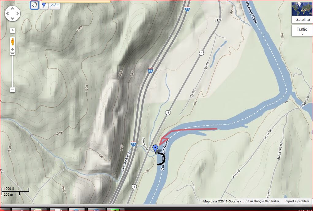 The blue marker shows where Roaring Brook enters. The black line is the approximate edge of the delta. The red arrow shows the channel/current crossing the river to the outside of the bend upstream of the delta so that much of the river flow is forced to go over and around the delta, creating enough current to erode a hole in the ice sheet over/near the underwater delta.
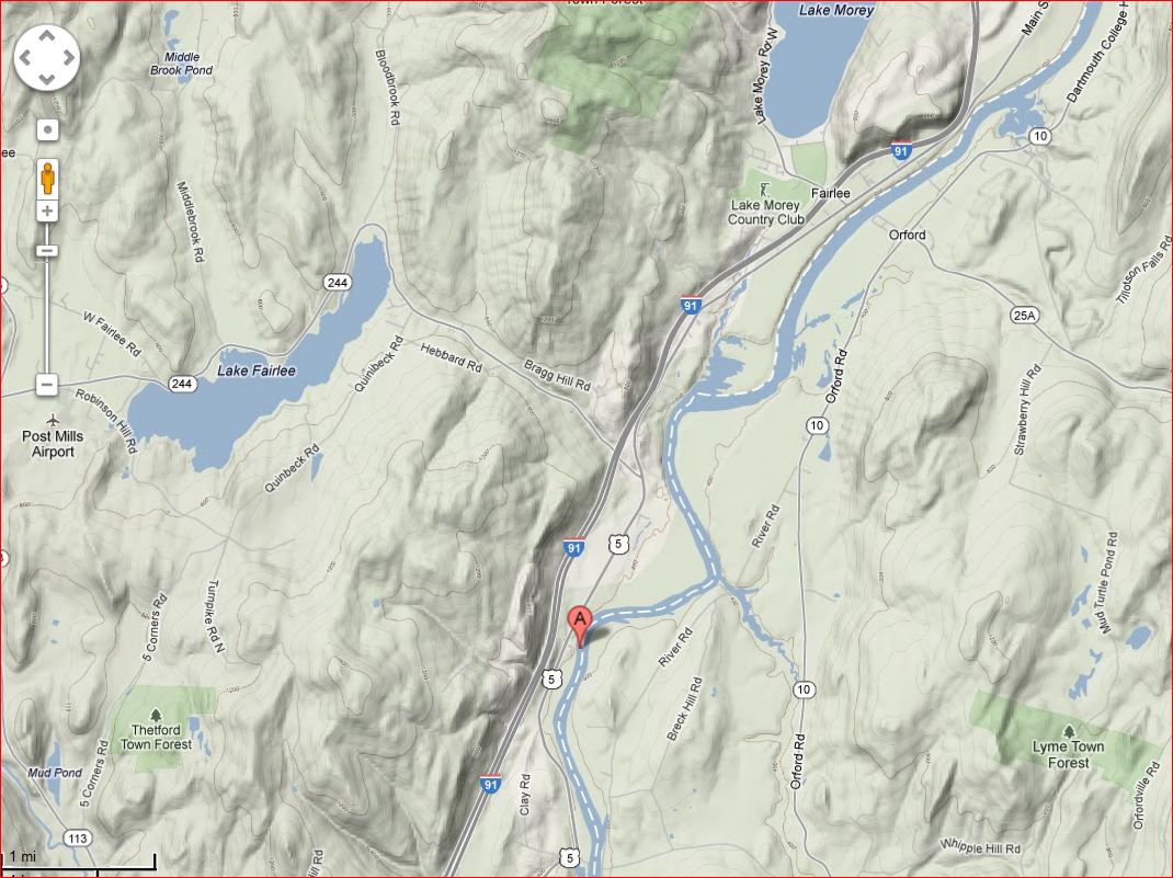 A larger scale map showing the location of the Roaring Brook Delta (red marker) in the Connecticut River about four miles south of public boat launch just south of Orford NH. This hole was not open during a late January 2014 visit but it looked like it had been in a recent warm spell.
Another open area was found about a mile south of Bradford Vermont in February 2014. We had a look at it in July 2014. It is the result of a rock rib that crosses the river and stirs up the flow of the river. Interestingly the holes were about 100 yards downstream from the rib.
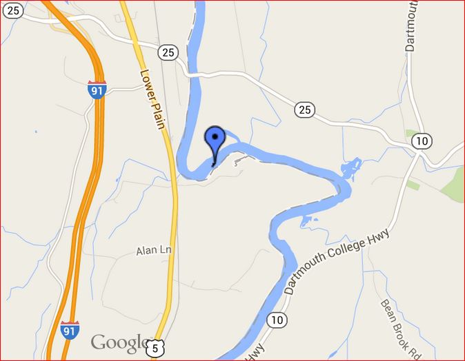
Location of the Bradford Hole
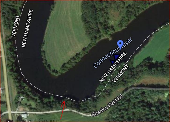
Close up of the south end of the rock rib can be seen on on Google Maps (red arrow). The entire river between the holes and the the turn to the north sould be considered suspect.
Bob

