Rangeley Lake Tragedy-December 30, 2012
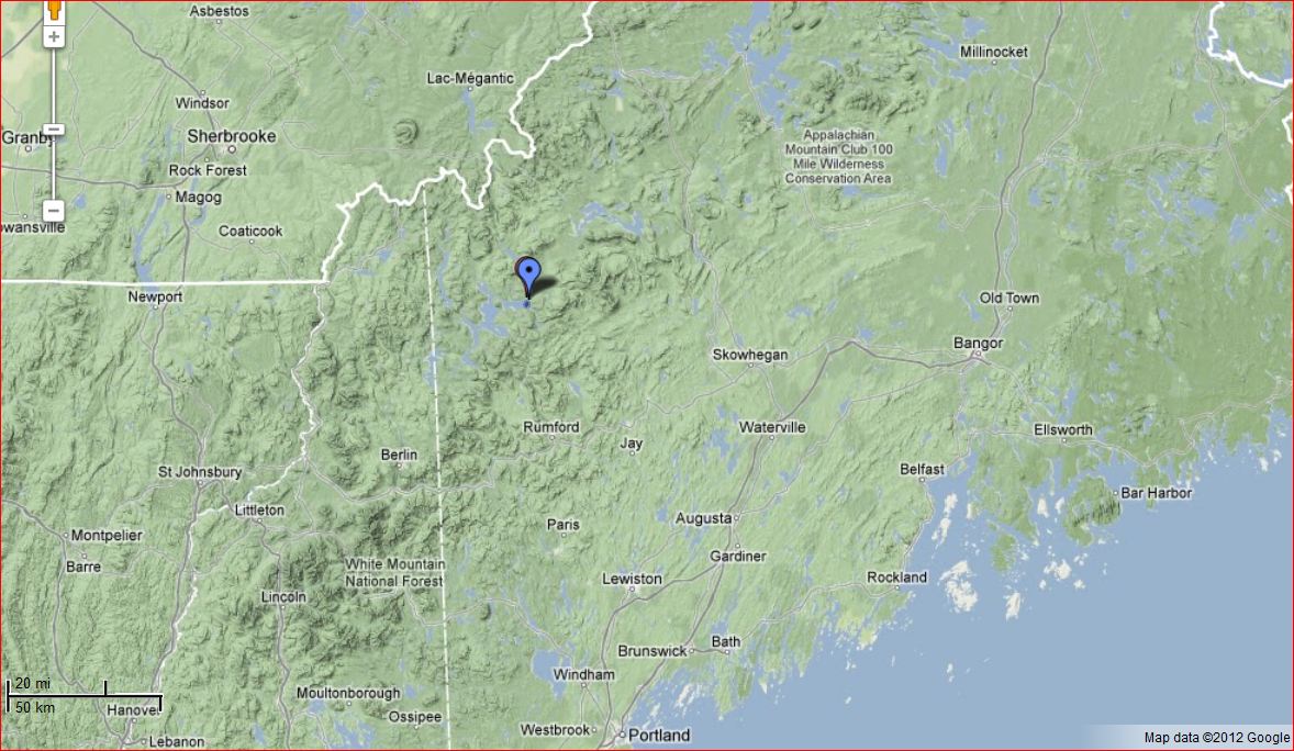
Rangeley Lake sits in the center of mountainous Northwestern Maine. The town of Rangeley is a popular destination for snowmobilers. Rangeley has a great local trail system that connects to a larger network of regional trails. With some snow in mid December and another dump on December 27 the season was off to a great start. Unfortunately it had been a warm fall and there was a mile diameter area of open water over the deepest part of the lake at the end of December. It took about nine days from when the ice came in on most of the lake until the open water froze. Based on the temperatures it probably took another 3-5 days to get thick enough to reliability support snow machines.
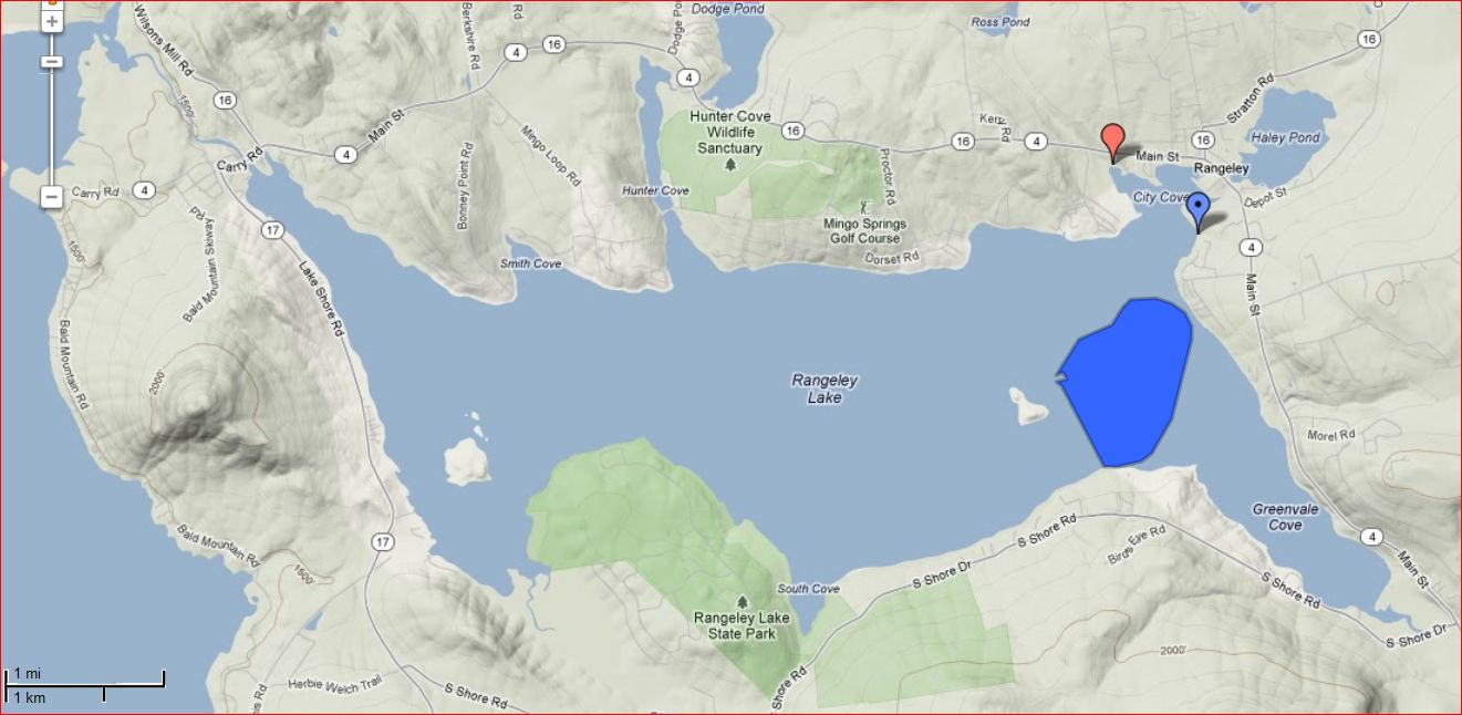
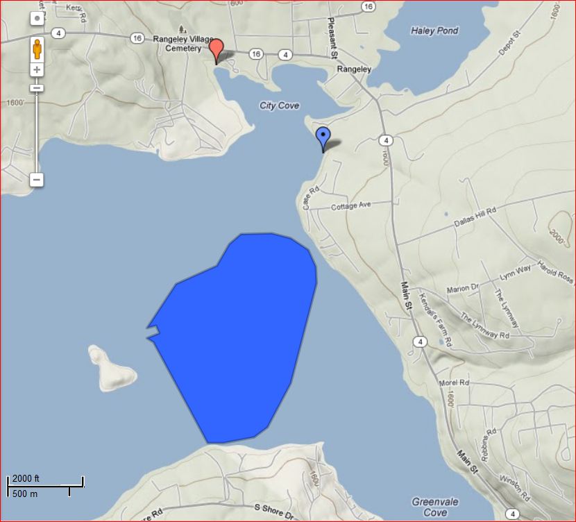 Estimated position of the open water from an aerial photo in the 1/3/13 Kennebec Journal. The blue marker is the probable intended exit point from the lake. The red marker is the other major snowmobile access to the lake near City Cove. (maps from Google Maps)The present understanding of what happened on the cold, windy night of December 30th, is five snowmobilers went on the lake from the 'Moose Alley' connector trail (red marker) probably intending to go to the connector trail just south of town to take them back to the main trail system (blue marker). They apparently got lost in the darkness and blowing snow. It is believed that they all ended up driving into the open water roughly half a mile beyond the entrance to the southern connector trail (blue marker). One of the riders was able to get onto the ice as his machine went in, only getting wet on one leg. He was the only survivor. He promptly called 911. A rescue was attempted by the local rescue group in difficult and dangerous conditions. The snowmobile tracks indicated that three of the group broke off with the first two sleds. They went roughly 1/4 mi further out on the ice before falling in themselves. The body of the first person was recovered the next morning with one sleeve frozen to the ice. The other three were not recovered until the ice went out in early May. This is being described as the worst snowmobile accident in the state's history.
Note: A link to a Maine Public Radio no longer connects. The article offers some good insight and perspective from some Rangeley residents on the importance of getting local information before going on any ice covered water. (Note: the open water is described as being in the Greenvale Cove. As you can see on the above maps it was really in the main lake. Greenvale Cove is usually one of first coves to freeze.)
Click here for a January 3 article
Click here for a follow up published in the Waterville Morning Sentinel February 20, 2014 by Amy Calder
I visited the ice on January 1 and 2. The the three ice samples sawed out of the ice (at sheet a safe distance from the open water) ranged from five to ten inches thick. I did not find any features like layered ice or pressure ridges that contributed to the accident.
If you ride a snow machine, the following are a few things you might find useful to watch or read while you are on this site:
1) Dr Gordon Giesbrecht's Getting that Sinking Feeling video on driving a sled fast into open water at night. It dramatically demonstrates the value of flotation type suits.
2) Another Giesbrecht video: You're Out, Now What? shows how to survive overnight in the back country after a breakthrough.
4) Key Points of reducing risk on lake ice
Other pages of the lakeice site that relate to this tragedy include: Giesbrecht Videos, Polynys, Accident Accounts, Clawless self rescue, etc. Most of these pages have additional links.
The following are links to manufacturers of snowmobile suits that provide flotation and a significant improvement in the odds of surviving falling through with a snowmachine:
Life jackets or float coats are a reasonable alternative for lake ice travel.
It has been a tough week in Rangeley. I offer my condolences to family members, friends and the Rangeley snowmobile community in general. While this may seem like an inappropriate time to bring up safety suggestions, it is the time when people are most willing to take them seriously.
Bob January 2013
UPDATE: May 3 ,2013
It reached 80 degrees on May second. From the MODIS satellite images these last few days, it looks like the ice is either out of the lake or very close to being so. The following are some images of the ice. The first is from 2011 and the others are from this ice season.
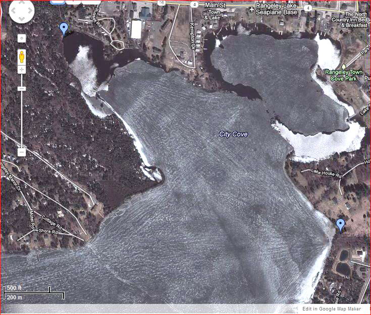
This above is from Google Maps and was taken on May 5, 2011. It gives a idea of the amount of snowmobile traffic there is on City Cove. The two blue markers show the ends of the connector trails to the lake. 'Cove cutting' is driving between the markers to get to the other end of town without having to trailer the sleds or travel about 20 miles on the trail system (driving sleds on plowed roads is not permitted by state law for safety reasons).
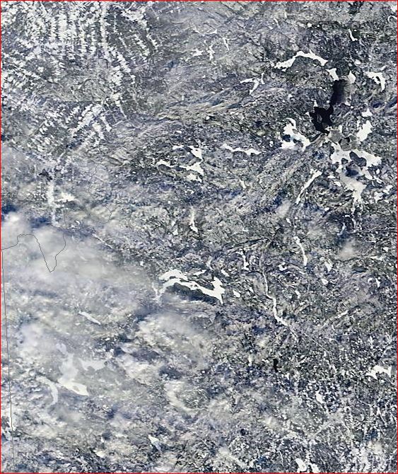
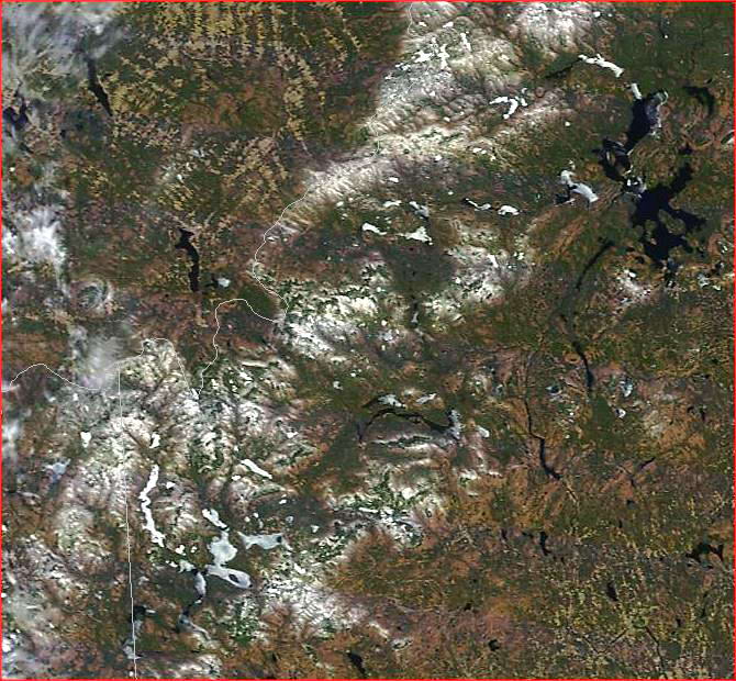
The following are MODIS images from the 2013 ice season of the ice in NW Maine. These images have a pixel size of about 800 feet so they do not show detail smaller than that. If you expand the satalite images they just get pixelated.
If you are not familiar with the area it may take some time to find the lakes and features. Having google maps open in satellite view helps to find features like islands in the lakes that may look like open water and fields that will be snow covered in winter and can look like snow covered ice.
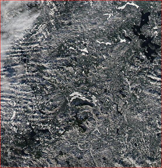
Above: 12/13/2012: Umbagog Lake is in. Rangeley, Mooselookmaguntic, Cupsuptic and the Richardsons are not frozen yet. Flagstaff has a big open area or black ice on the east end and a larger area of the east end with newer ice and drifted snow (light grey color). Aziscohos is covered but has a couple large holes two miles north of the dam.
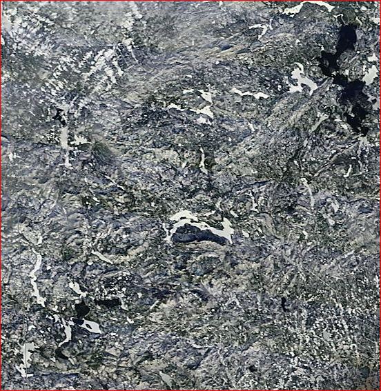
Above: 12/26/2012: Snow covered ice on Rangeley Lake is in only on Greenvale Cove and the cove by Oquossoc. The rest is black (and could be water or new, black ice). The days in between these images were too cloudy to see the ground.
December 31, 2012: Rangeley lake is ice covered on except for the open open water just north of Greenvale Cove. The open water was over the deepest part of the lake.
It looks like most of the lake may have came in on December 26 as that day had light winds and an overnight temperature of below zero. There was a significant snow storm on the 27th.
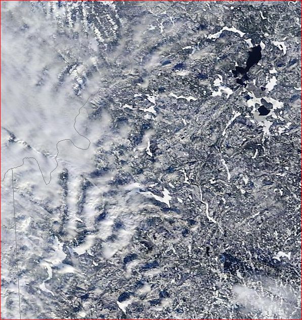
January 3, 2013: The open water is plainly visible on the east end of Rangeley Lake. It froze on the 3rd or 4th during a cold snap and light winds. The open area froze about nine days later than the rest of the lake which froze on about December 26. Open areas this size are kept open by wind and/or warm weather.
The open water reappeared in late April a week or so before the ice went out. This is partly a result of the seven or so thaws that occurred in January and February. It is common for late freeze areas to show up as darker grey ice during the thaw, probably because the ice is type 2S (small grain size). As appears to be the case here, sometimes they are the first place for the ice to melt all the way through the ice sheet.
There are MODIS images available back to 2007. There were no similar delayed freezing events of this duration since 2007, although it is likely that they occur from time to time. Large open areas like this are common on other lakes like Lake Champlain.
The estimated ice in/ice out dates based on the MODIS images and the weather history are:
- 2008 Ice Season: Ice In: December 10-15, 2007 Ice out about April 5
- 2009 Ice Season: Ice in: before 1/15/09 (no data). Ice out about 4/27
- 2010 Ice Season: In by 12/23/09 Ice Out between 4/13/2010 and about 4/20
- 2011 Ice Season: In on 12/17/2010 and out shortly after 5/5/2011
- 2012 Ice Season: Probably the ice came in on Jan 4 but maybe Jan 9. Ice out: about April 12-14th
- 2013 Ice Season: Ice in: January 3 or 4, 2013. Ice out: probably May 2
- 2014 Ice Season: Ice in: Aprox December 12, Ice out: Some probable dark ice on southern Mooselookmeguntic, Rangeley and Aziscohos lakes on May 8. On May 12 it looks like it is gone (but the satellite images are not great).
Note: In this report, 'Ice In' means there is an ice cover on the lake. It may be too thin to snowmobile on. 'Ice out' means the ice is gone from the lake althuogh there may be a little in a few protected areas.
Full freeze-over: The MODIS images are nice but the best way to know what is going on with the ice is to look at it, preferably from a high vantage point like Dallas Hill for Rangeley Lake or Height of Land for Mooselookmeguntic. The view from an airplane is even better. Pictures are very helpful for capturing the details. Once you have the big picture you should visit the ice and see what the ground truth is.
A method for predicting lake freeze-over was proposed in this paragraph on May 3, 2013. It was based on the accumulated freezing degree days (FDD) starting on November 1. It did not work well for the 2013-14 season when there were only 114 FDDs between November 1 and freeze-over. In 2012-13 there were 212 FDDs before freeze-over. That is too much variation for this method to be of much use.
Bob May 4-2013 updated 5/8/14
**********************************************************************
Update May 8, 2013
Putting up risk information signs at lake access points will help riders who are new to ice to better understand what they are dealing with. This seems especially important for the Moose Alley and the Rangeley Saddleback Inn connector trails (as shown here). In the past, signs about conditions were posted a number of places around town. Signs are not read every time someone goes by one but sooner or later most people will read them.
The current practice by rangeleysnowmobile.com of publishing time sensitive ice safety information in their trail condition reports is a good one. Putting some suggestions about reducing ice+snowmobile risks on the Safety Tips page would provide more perspective on lake ice who are not experienced with riding on lakes. Click here for an example of ice tips for snowmobiles.
The odds are that the conditions that led to the tragedy in December will not occur the same way any time soon. On the other hand, it is likely that we will see more late freeze-over dates and warmer winters so we can expect more lake-ice problems in the future.
Bob
Note this update has been modified since May 8, 2013
******************************************************
Update May 11, 2013: Recovery Restarted
Click here for an article from the Kennebec Journal
The first of the three remaining riders was recovered by the Maine Warden Service on May 10th from very deep (130 ft) water using a remote controlled underwater vehicle.
On May 15th the two remaining men were recovered.
